





Glasgow City Council introduces consultations to enhance active travel network
 Reading time: 3 minutes
Communities in north and south Glasgow have been asked to help shape plans to bridge the key gaps in the city’s active travel network, with consultations starting on proposals to improve the safety, ease and accessibility of local journeys.
The consultations concern five routes - Shields Road and Maxwell Road in the south, and Maryhill Road, Bilsland Drive and North Canal Bank Street in the north.
They would help join up current and planned walking, wheeling and cycling links, delivering a more connected network across the city.


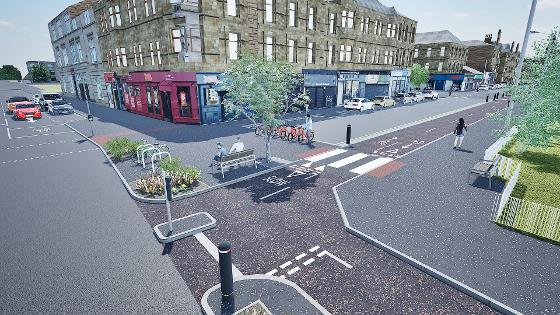
Alongside new and upgraded active travel routes, the proposals include enhanced pedestrian crossings, more accessible footways, improved public spaces, new planting, sustainable drainage, seating and other additions to facilitate safer and more attractive streets.
The five routes are part of Connecting Glasgow, which is the council’s new active travel delivery programme, which aims to ramp up implementation, remove gaps in the network and effectively use external funding opportunities as they arrive.
The feedback from the north and south consultations will help refine designs, so the projects have a stronger chance of securing construction funding.
The proposed route on Maryhill Road in the north would connect Connecting Woodside’s Garscube Road with Bilsland Drive, where current cycle lanes would be upgraded to fully protected segregation.


The improved route would then continue towards Balmore Road and future connections on Hawthorn Street - while proposals for North Canal Bank Street would remove the gap between Borron Street and Pinkston Road, boosting links to the canal and Sighthill.
New infrastructure on Maxwell Road in the south would connect the South City Way at Pollokshaws Road with a new route on Shields Road - which would then connect to the South West City Way.
Councillor Angus Millar, city convener for Transport and Climate, said: “These proposals are about filling in the key gaps of Glasgow’s active travel network so that more people can make everyday journeys safely and confidently by walking, wheeling and cycling.
“The routes in the north and south have real potential to join up communities with schools, local centres, public transport and existing active travel routes, while also creating better streets and public spaces along the way.”
Millar added: “We now want people who live, work, travel through or visit these areas to look at the plans and tell us what they think.
“Local feedback will be crucial in shaping designs that work for communities and help us move these projects closer to delivery.”
For both sets of routes, consultation will go on for six weeks until 15 November 2026, with online surveys open throughout and public drop-in events going ahead in October.
The locations and timings for the drop-in events are:
- North- Maryhill Road, Bilsland Drive and North Canal Bank Street; Tuesday 20 October, 3.30pm to 7.30pm; Mackintosh Queen’s Cross Church, 870 Garscube Road, G20 7EL
- South- Shields Road and Maxwell Road; Wednesday 28 October, 3.30pm to 7.30pm; St Ninian’s Church Hall, 1 Albert Drive, G41 2PE
At Maryhill Library, Pollokshields Library and Exchange House on George Street, paper copies of the surveys are available.

Share this article:

Subscribe to our newsletter to not miss articles like this one:
 SUBSCRIBE