


Caledonia Water Alliance wins award for safer sewer surveys

The award-winning team
Along with Environmental Techniques, Good Friday Robotics and Scottish Water, Caledonia Water Alliance (CWA) has won the Pipeline Industries Guild Utility Pipeline Technology Award 2022 for adapting drones for advanced, safer sewer surveys.
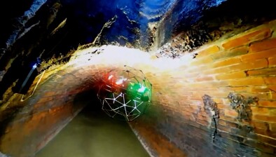
Many sewers in Scotland are difficult to survey using traditional CCTV techniques such as crawler cameras, float surveys or walkthrough surveys. The drone technology has therefore been developed to allow us to have access to the sewer network.
The technology has been trialled and developed over several months before finally being used on a project in Glasgow.


The key benefits of the drone surveys include; reduced time in confined spaces and lower risk to operatives, as the drone can be flown in from the ground surface with less need to enter manholes.
As the drone flies near the top of the sewer, it isn’t restricted by uneven inverts, narrow channels, debris, high flows, etc. This allows us to complete surveys on more critical assets than solely using the traditional techniques.
The reduced number of operatives and vehicles required on site makes the drone survey have a much smaller carbon footprint. Drone surveys can be completed safely with two- and three-men crews compared to nine for a safe man-entry walkthrough, as well as reducing the need for jetting and flow control.
WinCan reports detailing structural and serviceability condition grades can be completed automatically, improve productivity and reliability of results. The drone records 4K footage of the sewers with effective LED lighting. The higher elevation of the drone camera in the sewer also allows a high level of detail to be observable even when there is a lot of debris in the line.


LiDAR 3D cloud mapping In addition to recording high quality video footage of the assets, the drone is also equipped with a LiDAR scanner that produces a 3D map of the asset. The map can then be interrogated using 3D software to measure dimensions, levels of debris, deformations, connections, etc.